
- Attractions
- Activities
- Lodging + Campgrounds
- Area Info
- Services
- Transportation

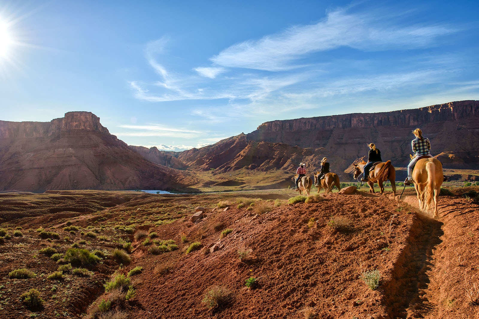
Horseback Riding
This page is designed to give you general information on equestrian trails. It also gives approximate time needed for each trail. The estimated times do not allow for side trips and stops. Always carry a map of the area and take plenty of water for your pack and saddle stock.
Trail Length: 2 hour ride
Terrain: Sand and Sandstone
Land: Bureau of Land Management (See below for regulations)
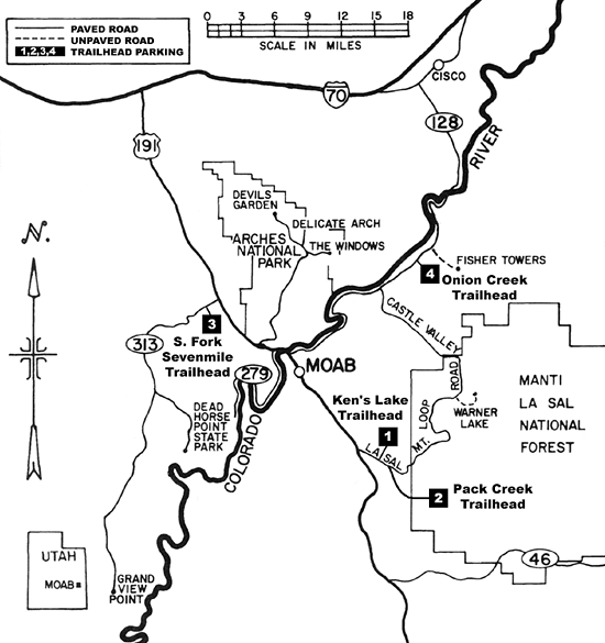
Trailhead Directions: Go South from Moab on Hwy 191 turn left at mile post 118 onto Old Airport Road. Turn right onto Spanish Valley Drive .5 miles. Turn left to Ken’s Lake, continue past the campground entrance .2 miles to the horse trailhead to park.
Trail: From the parking area ride towards the lake and cross the creek. Follow the road between the lake and the red cliffs to the east. The sandy parts of the road are a good place for a loop. As you pass the lake there is a road turning left to loop around the lake, or you can continue north and explore the ridges below the cliffs.
Trail Length: 4.5 hour ride
Terrain: Dirt and gravel with loose rock
Land: Forest Service(See below for regulations)
Trailhead Directions: Go South from Moab on Hwy 191, turn left at mile post 118 onto Old Airport Road. Turn right onto Spanish Valley Drive .5 miles. Go past the Ken’s Lake turn off and continue on the La Sal Mountain Loop Road. Turn right towards Pack Creek Picnic Area onto Pack Creek Road. Park just past the Pack Creek Picnic Area. The trailhead is back before the cattleguard you just crossed, west of the picnic entrance. (There is a gate to bypass the cattleguard).
Trail: Just before the cattleguard at the picnic area entrance, ride up USFS 719, a gravel road going to the south just before the USFS Pack Creek Campground. Stay on the gravel road as it climbs through an easement of private property. Go past a minor road to the left, and an old cattle loading ramp on the right. Continue gaining elevation until you reach a fork in the road. Take the left fork for another mile. The road ends and the trial begins with a creek crossing. Continue riding up the trail, which will eventually climb to 10,000 feet at La Sal Pass. This part of the trail is best for experienced riders and stock. There are incredible views of the mountains along this trail.
Trail Length: 4.5 hour ride
Terrain: Sandy Wash
Land: Bureau of Land Management (See below for regulations)
Trailhead Directions: Go North from Moab on Hwy 191, nine miles out of Moab. Turn west onto Hwy 313, and park at the fourth possible left turn. You will park on a flat area next to the road, and there is plenty of room to turn around. (If you start to climb a hill on Hwy 313 you have gone to far). Ride down the dirt road and follow the canyon to the south.
Trail: Follow the jeep route up the wash. Stay in the main canyon. Side canyons are impassable, and impossible to ride. At the end of the canyon is a grotto, which is usually has a pond. The water is not for human consumption.
Trail Length: 4 hour ride
Terrain: Dirt and gravel road
Land: Bureau of Land Management (See below for regulations)
Trailhead Directions: Go North from Moab on Hwy 191 and turn right onto Hwy 128. Turn right on a road marked Taylor Ranch at mile marker 20. After you turn you’ll see a small sign for Onion Creek.
Trail: Park at the parking area before the first creek crossing within the first mile. You can continue on over the bridge and meet up with the Stinking Spring.
Equestrians are required to feed weed-free hay to pack and saddle stock while using BLM land. Although horses are not restricted to designated roads and trails, resource damage is lessened when all riders stay on the same route.
The Ken’s Lake, Upper Onion Creek, and Lone Mesa Campgrounds have group campsites that can specifically accommodate pack and saddle stock. However, pack and saddle stock are allowed at any BLM campground. Other campgrounds that are suitable for pack and saddle stock trailers are Courthouse Rock and Hittle Bottom Campgrounds. Please clean-up waste as a courtesy to other campers.
For additional information contact the Bureau of Land Management at 435-259-2100.
For additional information contact the Manti La Sal National Forest at 435-259-7155.
Pack and saddle stock may be taken on all backcountry roads and in Horseshoe Canyon. Cross-country travel is prohibited. Pack and saddle stock include horses, burros or mules. All other domestic animals are prohibited in the backcountry. All pack and saddle stock use requires a backcountry permit, which may be obtained at district visitor centers.
Lack of water is a limiting factor for pack and saddle trips in Canyonlands, as only a few areas have reliable sources. Contact the park for recommended destinations.
Stock must be fed pelletized feed for 48 hours in advance of and for the duration of the trip in order to prevent the spread of exotic plant species. Animals may not be left unattended and must be staked at least 300 feet from water sources and away from vegetation where possible. Park vegetation may not be consumed. Animals may not be unstaked and hobbled.
Day use permits are unlimited and free of charge, except in Horse/Salt Creek and Lavender Canyons in the Needles District, where day use is limited to seven animals per day. In these areas, permits are available through the reservation system and fees are charged. In all other areas of the park, including Horseshoe Canyon, group size must not exceed ten animals and ten people.
Overnight trips must stay at designated vehicle camps. Permits are $30. All manure and feed must be packed out from the campsites. The group size limit is seven people and ten horses for the Needles and Island in the Sky, and five people and eight horses for the Maze and Orange Cliffs. Overnight use is not allowed in Horseshoe Canyon.
Park Headquarters
435-719-2313
Island in the Sky District
435-259-4712
Needles District
435-259-4711
Maze/Horseshoe Canyon
435-259-2652
3310 Spanish Valley Drive
Moab, UT 84532
435-259-1400
3300 Spanish Valley Drive
Moab, UT 84532
435-259-6226
Note: Overnight boarding available with paid lodging.
24 stalls & arena.
Highway 128 – Milepost 14
Moab,
UT
435-259-2002
4575 Spanish Valley Drive
Moab, UT 84532
435-259-8710
For a more optimal web experience, please view our site on Microsoft's recommended browser, Edge. You can download it here.